How To View 3D Buildings in Google Maps On Android
News
By
Mark Spoonauer
published
Join the conversation
Add us as a preferred source on Google
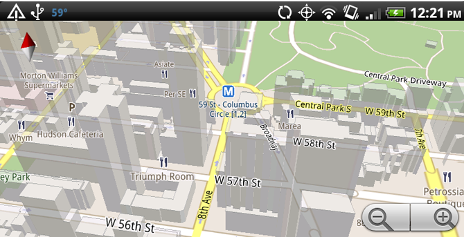
The new 3D maps in Google Maps don’t just look good, they’re extremely useful when you find yourself in a large city. For example, in New York, you can more easily tell what side of the street an address is on when you have a map that displays 3D buildings.
Step by Step
- Search for an address or point of interest in Google Maps.
- Pinch to zoom in so that you’re as close to street level as possible. Provided you’re in a large city, you’ll see a 3D building start to fill the screen of your Android phone.
- To change the perspective from birds-eye view to closer to the ground just drag two fingers down on the display of your handset.
Get The Snapshot, our free newsletter on the future of computing
Sign up to receive The Snapshot, a free special dispatch from Laptop Mag, in your inbox.

Editor-in-Chief
Responsible for the editorial vision for Laptopmag.com, Mark Spoonauer has been Editor in Chief of LAPTOP since 2003 and has covered technology for nearly 15 years. Mark speaks at key tech industry events and makes regular media appearances on CNBC, Fox and CNN. Mark was previously reviews editor at Mobile Computing, and his work has appeared in Wired, Popular Science and Inc.
MORE FROM LAPTOP MAG...

